
The Parkway
|
Minnehaha Parkway is the second major route along the
Twin Cities Marathon Course. Starting
at Lake Harriet, the Parkway
follows Minnehaha Creek meandering through South Minneapolis until it joins
Lake Nokomis. From there, the route takes you further east until you
reach Minnehaha Park, the start of the Mississippi River Road.
|
Click on the map for a larger image
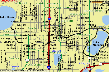
Distances: 4.1 miles from Lake Harriet to Lake Nokomis -- One Way (+2.7 miles if you loop Lake Nokomis) (+1.5 miles from Lake Nokomis to Minnehaha Park) |
||
| Water: Several water pumps along the way. | ||
| Recommended Start Point: East End of Lake Harriet. | ||
| Parking: Free and plentiful on nearby streets. | ||
| Diversions: The spectacular homes lining the Parkway |