
The River Road
|
It's beautiful. It's historic. It's uncrowded. And it offers the runner several distances from which to choose. That's why the Mississippi River Road
is my favorite running venue. Let the rest of the city mob The Lakes, I'll stick to The River. Paved paths line the entire stretch of the river from the Ford Bridge to the Washington Bridge on both sides. Fountains along the way will keep you hydrated. The river is an ideal training ground as you can choose your distance based on your starting point and the bridge to make your loop. From Minnehaha Park you can do 6 miles, 9 miles, and 12 miles. Or, start from the north end of the river and do 3 miles, 6 miles, or 12 miles. A good portion of the River Road forms the third major route along the Twin Cities Marathon Course. |
Click on the map for a larger image
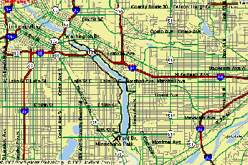
Distances: Entire loop - 12 miles (Minnehaha Park to Washington Bridge loop) 9 Miles - (Minnehaha Park to Franklin Ave. Bridge loop) 6 Miles - (Minnehaha Park to Lake St. Bridge loop) 3 Miles - (Start at Washington Bridge to Franklin Bridge loop) |
||
| Water: Several water pumps along the way. | ||
| Recommended Start Point: Minnehaha Park | ||
| Parking: Paid parking at Minnehaha Park. But free and plentiful on nearby streets. | ||
| Diversions: Look for palatial estates in St. Paul, the U of M in Minneapolis and crew teams training on the river. |