
Pike Island
|
Located in Fort Snelling State Park, Pike Island is a remote place in the middle of the Twin Cities. You're on the Minnesota
River here, just below historic Fort Snelling. Pleasure craft may whiz by, but mostly the shoreline is quiet. The 5K loop of the island is
easy and flat. For longer distances consult the posted maps which show you the trail system. Besides Pike Island, trails leading
North will hook you into Minnehaha Park and the River Road. Trails South will lead you to the other side of the park, where
you will be directly under the flight paths of the MSP airport. Avoid this area unless you prefer to see closeups of jet aircraft.
|
Click on the map for a larger image
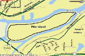
Distances: 3 Mile trail to loop Pike Island (Refer to Posted Maps for other trails/distances) |
||
| Water: At Park headquarters. | ||
| Recommended Start Point: Directly underneath Fort Snelling near main parking lot. | ||
| Parking: Paid Parking or free with State Park sticker. Enter Park via Post Road. | ||
| Diversions: The Deer and wildlife on the island. Birdwatching while you run! |